25 July 2019 (Chania, Crete) – One of the recently published books I brought with me this summer is Archaeology from Space by Sarah Parcak which shows the evolution, major discoveries, and future potential of the young field of satellite archaeology. I saw Sarah at one of her TED Talks, had the opportunity to chat with her afterwards, and I was captivated by her work. In her book she writes about some surprise advancements in satellite imagery after the declassification of spy photography, plus her new map of what once was thought to be the “mythical” Egyptian city of Tanis. She actually makes space archaeology not only exciting, but urgently essential to the preservation of the world’s ancient treasures.
She is clearly a pioneer in the use of remote sensing, via satellite, to find and map potential locations that would otherwise be invisible to us. Variations in the chemical composition of the earth reveal the ghost shadows of ancient walls and citadels, watercourses and planting fields. The nifty kid-friendly name for all this is “archeology from space” (hence the title of her book) but that’s a bit of a misnomer, because, technically, the satellites in question are in the mid-troposphere, and also the archeology still happens on, or under, the ground. In spite of the whiz-bang abracadabra of the multispectral imagery, Sarah says she is, at heart, “a shovel bum”.
In brief, Sarah has worked in twelve countries and four continents, using multispectral and high-resolution satellite imagery to identify thousands of previously unknown settlements, roads, fortresses, palaces, tombs, and even potential pyramids. From there, her stories take us back in time and across borders, into the day-to-day lives of ancient humans whose traits and genes we share.
I had also recorded a few video and audio interviews she did in the run-up to the publication of her book and I had the opportunity to watch them, listen to them. A short selection of my favorite bits:
1. In one of her video interviews she showed a satellite image of a section of Egypt:
See those black specks everywhere? Those are looting pits.
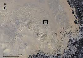
All made since the Revolution in 2011. Once my team and I make the G.P.S. coördinates, we fan out on the ground and assess the damage.
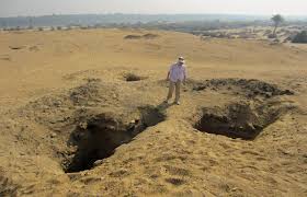
We can map thirty to forty tombs a day. Looters can hit a couple of tombs in a night. They just blow through twenty metres of dirt, with shovels and buckets.
Her back-of-the-napkin estimate of the post-2011 losses, taking into account the thousand-plus looted tombs and the auction prices of coffins, statuary, and jewelry (which you can track on the regular web, the Dark Web and through networks tracked by government agencies) is about $146 million. Another estimate, based on satellite data: there are roughly fifty million unmapped archeological sites around the world. Many, if not most, will be gone or corrupted by 2040, she says, the threats being not just looting but urban development, illegal construction, and climate change.
2. In 2016, Sarah won the TED Prize, a grant of a million dollars; she used it to launch a project called GlobalXplorer, a crowdsourcing platform, by which citizen Indiana Joneses can scrutinize satellite maps and identify potential new sites, adding these to a database without publicly revealing the coördinates. The idea is to deploy more eyeballs (and, ultimately, more benevolent shovel bums) in the race against carbon and greed.
3. Her favorite course to teach is “Mythbusters: Archaeological Hoaxes, Scams, and Documentary Disasters.” She disdains a lot of what passes for popular archeology, such as the recent best-seller “America Before: The Key to Earth’s Lost Civilization” (“a dumpster fire of pseudogarbage,” she said) and the bogus but popular theory that aliens left behind the Pyramids of the Maya and the Nile: space archeology of a different kind. “This implicit idea that people of dark skin could never have built these amazing monuments themselves,” she said. “It leads into everything we’re seeing today. It’s white supremacy.”
4. In one interview she was asked “let’s say you want to find some new ruins from orbit. How do you start?” Her answer:
Before we even start looking, we spend a lot of time looking at articles and books. What are the types of features that you might find in this area? And then we start testing different algorithms, or different remote sensing processing techniques. It’s kind of like a detective investigation, right? We’re looking at what techniques, what satellites, what processing methods work — 999 times out of 1,000, you fail miserably, because … well, welcome to science! But you have those one or two things that may be a hint of something. And you just keep noodling at it until you figure out what works.
5. And why write a book? Well, to try and stop that fake news:
When you look at what books are in the archaeology section of a bookstore, it’s mostly these pseudo-archaeological books by people who write that aliens built pyramids or other outlandish theories. And that’s not what archaeology is.
Archaeology is this incredibly rich field that helps to show the full trajectory of our humanity, all the good and all the bad, all our creativity, all of our foibles, the fact that our common humanity hasn’t evolved in 300,000 years — while our technology has.
That’s really why I wanted to write this book. I wanted to show how archaeology really works, and what we actually do with the evidence we have, and how all these amazing new technologies are helping us to ask new, bigger and better questions about the past.
6. And how is space-based archaeology technology progressing? Well … just amazing :
We are very close to satellite imagery that has a resolution of three inches. Imagine being able to zoom in from space and see a shard of pottery — yes, we are really close to developing that.
The other thing is that the field is shifting from satellite to drones. We’re not quite there yet, but within a couple years, we’re going to be able to capture very high resolution hyperspectral data, and laser mapping from autonomous vehicles, and that is going to transform the field as much as satellite imagery has.
As my regular readers know, space has always fascinated me. Since a kid, really, when my delight was the yearly trip we made to an aunt and uncle who lived in Florida near Cape Canaveral which was the location of NASA’s launch complex. My uncle worked there and often got me into the facilities. It was a wonder. I watched many a launch, live, and got to meet space scientists and engineers and even a few astronauts-in-training.
Last year I had the opportunity to visit the NASA Ames research center in Mountain View California. That is the home of the wind tunnels that were used to define the blunt “reentry ready” shape necessary for the Apollo command module to safely return to Earth. It was 3-days of a deep dive into space technology. It was during that trip that I heard Sarah’s TED Talk. In the run-up to this year’s 50th anniversary of men stepping on the Moon for the first time I immersed myself in a stack of new material on the latest science and space technology, some of which I have been sharing with you.
So this summer, a reading agenda of space, climate change … oh, and pretty much all-things-science. Sometimes that glorious moon rising before me as I lounge on my “reading deck”. That spherical bit of unchanging, inanimate rock … captivating me with its romance and its beauty and urging me to read further.